
Potential fields (geobrain.physics.potential)#
Gravity and magnetics: the cheapest data in geophysics, and the least unique.
Operator |
Gives |
|---|---|
|
|
|
|
|
total-field anomaly, with induced and remanent magnetisation |
|
the vector field, component by component |
Surveys are PotentialSurvey2D / PotentialSurvey3D. EarthField carries the
inducing field’s strength and direction, which is what makes a magnetic anomaly
depend on where on the planet you are standing.
import torch
from geobrain.core import ForwardContext, ModelState
from geobrain.mesh import TensorMesh
from geobrain.physics.potential import (Gravity2D, PotentialSurvey2D,
                                        gravity_to_mgal)

mesh = TensorMesh(shape=(10, 20), spacing=(25.0, 25.0))
stations = torch.stack([torch.linspace(0.0, 500.0, 21, dtype=torch.float64),
                        torch.ones(21, dtype=torch.float64)], dim=1)
gravity = Gravity2D(PotentialSurvey2D(stations))

rho = torch.zeros(10, 20, dtype=torch.float64)
rho[3:6, 8:13] = -400.0                      # a light body
gz = gravity(ModelState({"rho": rho}), ForwardContext.of(mesh=mesh)).data["gz"]
print(f"peak anomaly {float(gravity_to_mgal(gz).abs().max()):.3f} mGal")
peak anomaly 0.409 mGal
Warning
These operators are strict about dtype=torch.float64. A float32 survey is
rejected rather than quietly losing precision in a kernel that sums a
contribution from every cell in the model.
Why gravity needs help#
A gravity anomaly does not determine a density distribution: many earths fit
the same curve, and the smooth ones fit it best. Depth weighting
(geobrain.optim.depth_weighting) stops everything migrating to the surface;
an IRLS sparsity pass sharpens the blur; and a second physics, magnetics, with
a different sensitivity to the same rock, is what actually breaks the tie.
Hence the joint example.
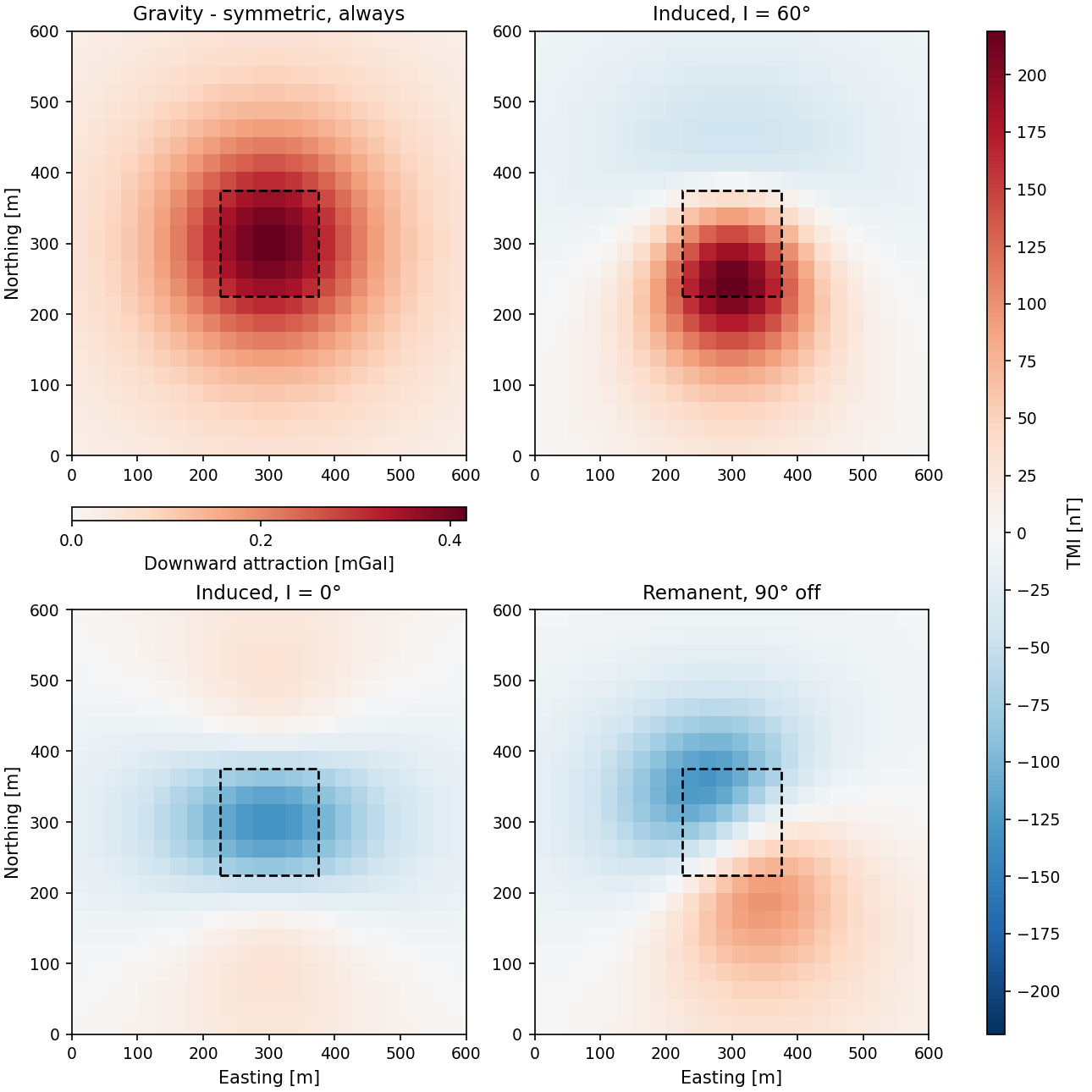
One buried body, four fields: gravity, induced magnetisation at two
inclinations, and a remanent case. From
examples/03_physics/06_potential_fields.py.#
Processing and interpretation#
upward_continue, reduce_to_pole, vertical_derivative,
horizontal_gradient, tilt_derivative, analytic_signal_amplitude and
regional_residual_lowpass are the standard filters. bouguer_slab,
bouguer_spherical_cap, free_air_correction and terrain_correction_prism
are the reductions. euler_deconvolution estimates source depth from a
structural index.
Units are SI inside and converted at the edge: gravity_to_mgal,
magnetic_to_nt, gravity_gradient_to_eotvos.
See also#
examples/00_showcase/01_gravity_inversion.py: the whole platform in three objects, on a gravity problem.examples/03_physics/06_potential_fields.py: why magnetics answers differently at every latitude and for every remanence.examples/03_physics/04_petrophysical_joint_inversion.py: gravity and magnetics together, answering which rock is where rather than how dense it is.