
Geological modeling (geobrain.geomodel)#
Everything that builds an earth before any physics touches it: geostatistics, implicit geological modelling, and the frames that carry the result.
The distinction the module is built around#
Kriging gives you the best single map: minimum error variance, and therefore smoother than the earth. Simulation gives you maps with the right variability, each one wrong in a different way. Which you want depends on the question: an average grade wants the estimate; a probability of exceeding a cutoff wants the ensemble, because you cannot read a probability off a smooth map.
Geostatistics (geobrain.geomodel.geostats)#
Category |
What is there |
|---|---|
Kriging |
|
Simulation |
|
Multiple-point |
|
Generative |
|
Variograms |
|
Transforms |
|
Validation |
|
A field, start to finish:
import numpy as np
from geobrain.geomodel import (FFTMA, CovarianceModel, GeoGrid,
                               PropertyMetadata, SimulationExecutionConfig,
                               VariogramKernel)

grid = GeoGrid(shape=(60, 40), origin=(0.0, 0.0), spacing=(10.0, 10.0))
model = CovarianceModel(nugget=0.0, structures=[
    VariogramKernel(kind=VariogramKernel.SPHERICAL, contribution=1.0,
                    ranges=(150.0, 60.0, 1.0e6), angles=(0.0, 0.0, 0.0))])

sim = FFTMA(model,
            property=PropertyMetadata(name="V", kind="continuous", unit="1"),
            execution=SimulationExecutionConfig(n_realizations=1, seed=7))
frame = sim(None, grid).realizations[0].frame
values = np.asarray(frame.to_numpy("simulation"), dtype=float).reshape(-1)
print(values.shape, f"mean {values.mean():+.3f}, sd {values.std():.3f}")
(2400,) mean -0.115, sd 1.078
Warning
The variogram ranges bind to the grid axes positionally, and a flat field
unflattens with x varying fastest, so values.reshape(NY, NX) is [y, x],
ready for imshow. Reshaping the other way round and transposing gives an
earth that still looks plausible and has its anisotropy mirrored. If your
sample locations stop sitting on the features they were drawn from, this is
why.
Frames and models#
Object |
Carries |
|---|---|
|
a regular grid domain: shape, origin, spacing |
|
scattered locations |
|
geometry plus named properties; what a kriging or simulation call takes and returns |
|
a property’s name, kind (continuous / categorical) and unit |
|
several coupled properties on one mesh, which a joint inversion updates together |
|
a named class with a code, because a facies is a name, not a number |
Implicit modelling (geobrain.geomodel.implicit)#
ImplicitModel builds geometry from what a geologist actually records,
namely surface points, orientations, series and faults, as the level sets of a scalar
field. It is differentiable with respect to the input data, so the
derivative of a unit’s volume with respect to a contact point’s position is
one backward pass, and a block model can be an inversion parameter rather than
a fixed input.
SurfacePointData, OrientationData, SeriesDefinition, FaultDefinition
and ImplicitModelConfig are the inputs; StackRelation says how series stack.
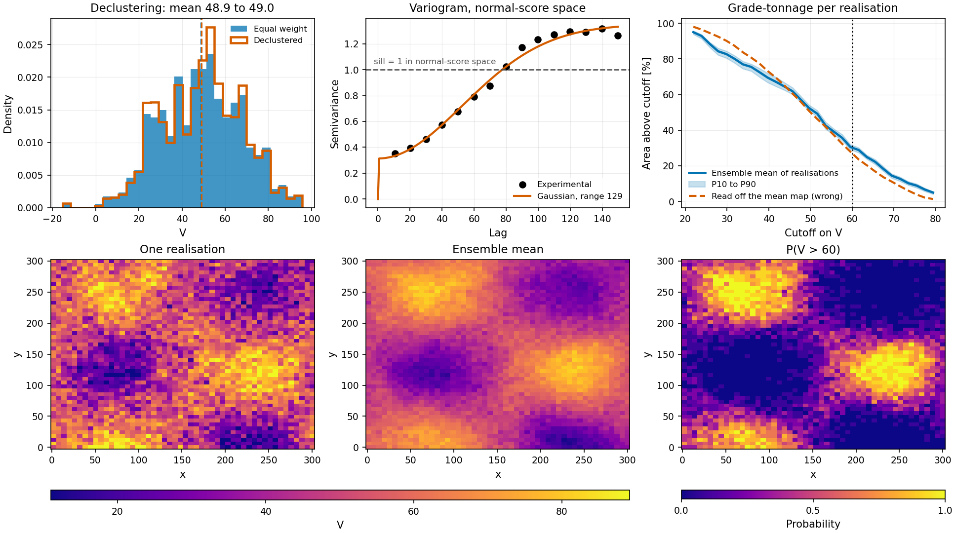
A study end to end, from a sample table to the probability a decision needs.
From examples/02_geomodel/07_case_study.py.#
See also#
examples/02_geomodel/01_estimation_vs_simulation.py: why the two answer different questions, measured on the same data.examples/02_geomodel/03_kriging_estimators.py: what each estimator assumes about the mean.examples/02_geomodel/06_implicit_modelling.py: geometry that carries gradients.examples/02_geomodel/07_case_study.py: decluster, transform, fit, simulate, and finish with a probability rather than a map.